
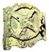
Antikythera
The remains of a clock-like mechanism determined to be a device for calculating the motions of the stars and planets.

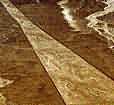
Piri Reis Map
A map found in 1929 was determined to be drawn by Piri Reis in 1513 showing the western coast of Africa, the eastern coast of South America, and the northern coast of Antarctica. The map was drawn 300 years before Antarctica was discovered and shows the coastline under ice.
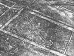
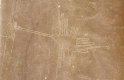
Nazca Lines
Geolyphs, clearly visible only from the air, created by the Nazca who lived in Peru 2000 years ago.
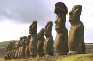
Easter Island - Moai Statues
Look it up.
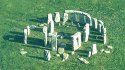
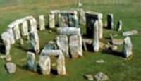
Stonehenge
Look it up.